
Glacial Landforms
Glacial landforms record glacial erosion and deposition long after ice has retreated and can have far-reaching implications for the geomorphic evolution of the landscape.
Learning Goals
- Identify the range of scales and overlapping impacts of glaciation on the landscape.
- Distinguish the types and formation mechanisms of a subset of glacial landforms.
- Relate glacial landforms to glacial behavior and the geologic past.
Glacial Landforms
As a glacier flows down its path, its ice is constantly moving and shifting the environment around it. From trees, to rivers, to mountains– little can stand in the way of a glacier. As a result, during this (often thousands of years long) flow of ice and material, rocks and debris are picked up, ground down, eroded, and deposited by the ever-shifting sea of ice.
However, though the actual processes of glacial erosion and deposition require the presence of glacier ice, the by-products of this erosion and deposition can be preserved in the landscape long after glacier ice has retreated, with the dynamics of glacial erosion and deposition preserved for all to see long after that story has ended.
The landscape immediately around a glacier can be quite barren. In this photo, from the base of Mount Fitz Roy, the mountain has been heavily reworked by glaciation, generating the large piles of glacial debris seen in the foreground and scouring out the lake just past the glacier terminus. Our group of researchers can be seen just below the lake and function as a scale to show just how massive these glacial features can be.
In this section we will walk through a subsample of some of the types of landforms that are generated by glaciation. This is, by no means, an exhaustive list of the complex ways glaciers modify the landscape. Instead, this is meant to give you a good picture of the variety of scales over which glaciers can rework their environments and how the results of glacial erosion and deposition can be seen on the landscape long after glacier ice has retreated.
Landforms on Many Scales
It is important to note that glacial landforms often occur on a variety of scales and can often be seen overprinted on top of each other (glaciers are quite good at their job of reworking the landscape, after all). Thus, it is important to keep in mind that a massive, hundred kilometer-long glacial lake that was formed as a glacier scoured out a lake valley can also have small, millimeter sized glacial sediment deposits that were also ground down and left by the mighty glacier. As a result, glacial features can be seen on all scales, from millimeters to kilometers.
A Bit about My Research and the Glacial History of Minnesota
In this section I define a number of glacial landforms through images from my fieldwork in Argentina to highlight what these landforms look like in a real-world, field setting. Though many of these photos are quite obviously from a glacial setting (i.e. taken standing on a glacier), it is actually possible to spot glacial features anywhere glaciation has taken place.
Minnesota is a prime example of this, with its own complex glacial history. Most places you visit in the state are shaped (and still being shaped (more on this in the next section)) by glaciation. In fact, many of the features I highlight here can be spotted in and around Minnesota. If you’re interested in learning more about this, I highly recommend checking out this website (put together by our own College of Science and Engineering) on Minnesota’s glacial history: Click Here.
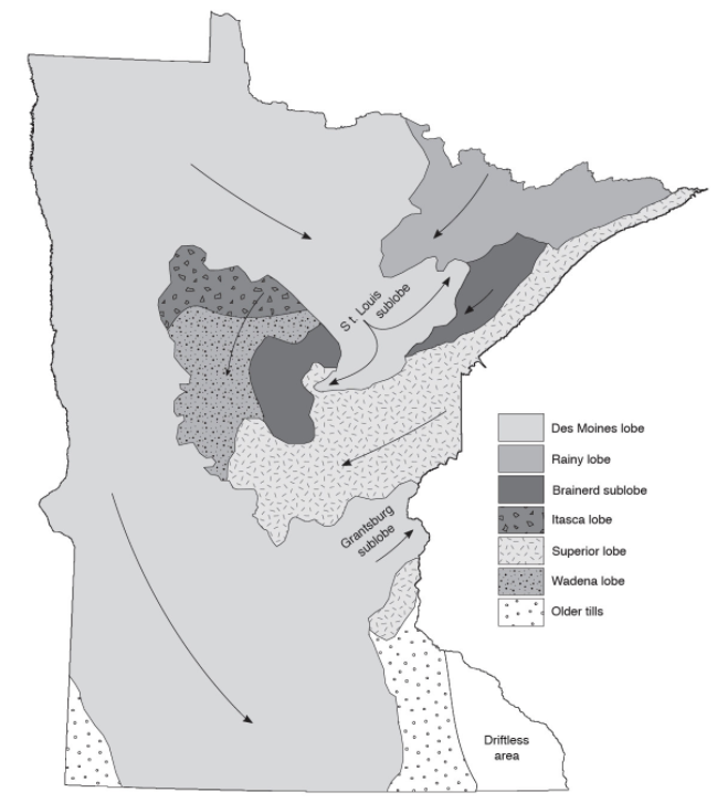
A simplified map of ice lobes in Minnesota during the Ice Age. From Lusardi (1994), as seen on the website linked above.
Erosional and Depositional Landforms
Glacial erosional landforms are formed by the process of glacial erosion. Both glacial abrasion and quarrying are highly efficient at scraping and moving material around. As glaciers erode, they can leave telltale signs of their erosion on the landscape. However, the material that glaciers transport cannot be carried indefinitely by the ice and will, eventually, be deposited. Glacial depositional landforms are comprised of material that has been deposited by a glacier.
Glacial Erosional Landforms
Outcrop Scale
Glacial polish is bedrock that has been scoured and polished by glacial erosion. These smooth bedrock faces are often marked with many other glacial erosional markings including glacial striations.
Glacial striations are scratches in the bedrock made by pebbles and debris as they are dragged across by glacial ice. Because of their linear nature, we can use glacial striations to narrow down the direction of ice flow. However, since we can’t tell which of the two directions the ice was flowing based solely on glacial striations, we often need other clues (including other types of glacial features) to tell us the direction of glacial ice. In the image below, I knew the ice flow direction based on the position of the modern glacier, but many times we are not that lucky.
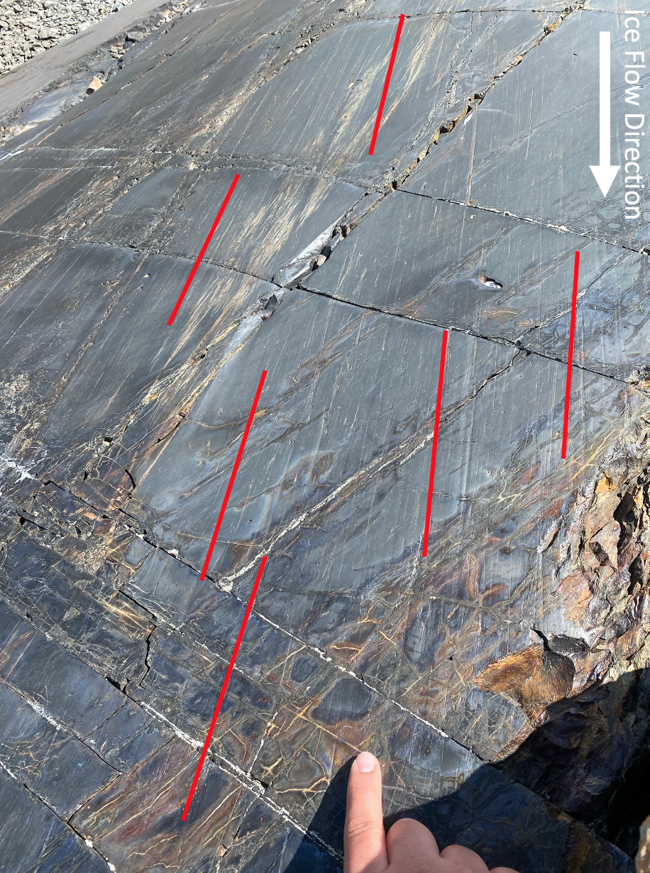
A photo of polished bedrock and glacial striations near the Upsala Glacier. We used these polished bedrock surfaces to take samples to determine when glacial ice last covered the rock. Polished bedrock was ideal for our sampling because nothing has covered this surface since the glacier last flowed over it (likely around the Little Ice Age (~1500 BC) or so).
It is important to note on the image above that there are also many bedrock fractures in the outcrop. These are formed from other geologic processes and not by pebbles sliding across the outcrop. This is a great example of how you can have many geologic processes (faulting, fracturing, rock weathering and glacial erosion) overprinting each other in a field setting.
Glacial chatter marks are a series of wedge shaped marks form from the sequential chipping of the bedrock surface by rock fragments dragged by glacial ice. As the glacier continues to flow, the fragment will become caught on the bedrock face until it builds up enough pressure to jump to another point of the bedrock, where it gets stuck again, creating a sequence of marks. I like to think of these as “footprints” of a small pebble, long since carried away by glacier ice!
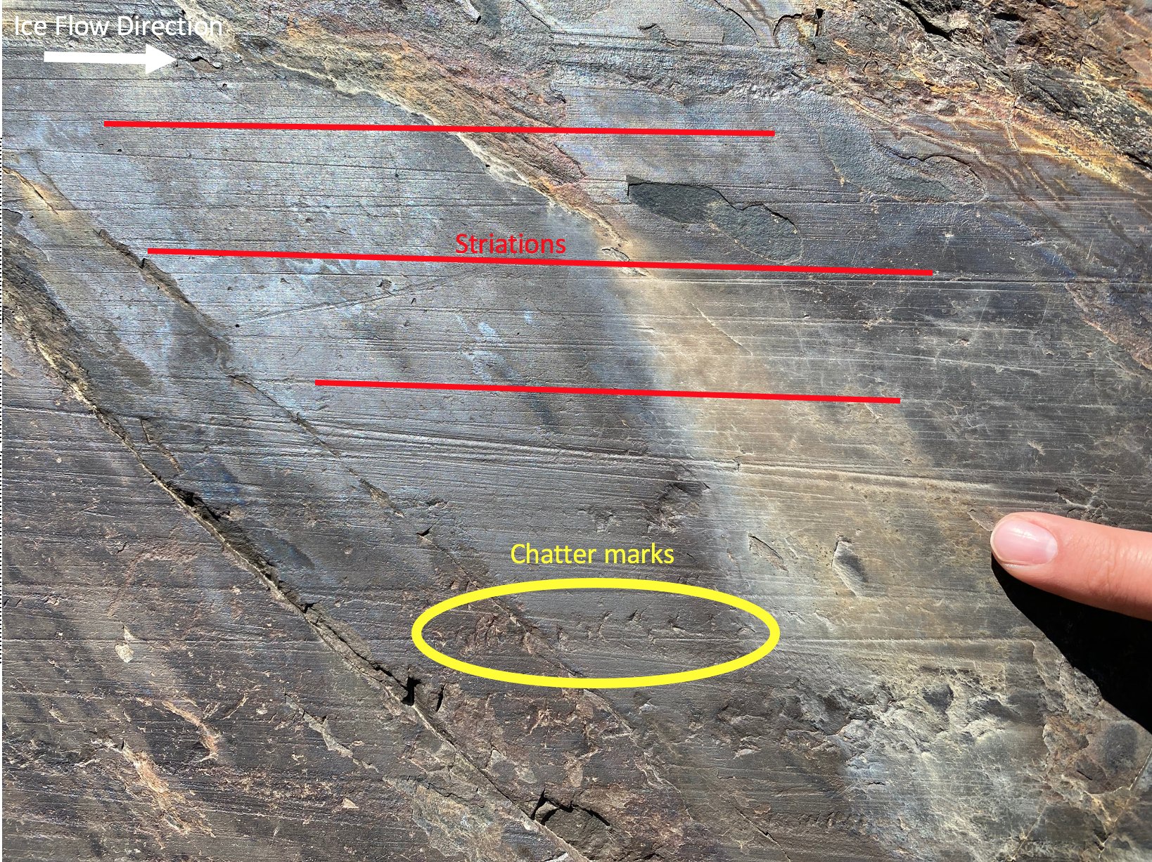
Glacial striations and chatter marks on a bedrock outcrop near Upsala Glacier.
Landscape Scale
As a glacier flows, any part of the surrounding environment that touches the ice is likely to get reworked, while those parts not in contact with ice remain intact. If the ice melts, a clear delineation between where the ice reached is often left on the valley wall. These features are called a glacial trimline, or a delineation on the wall of a glacier valley that shows the previous thickness of a glacier.
A trimline on the valley wall of Perito Moreno Glacier. Notice how the line can be traced far up the valley. This picture was taken as our team stopped for a break during our hike up the ablation area of Perito Moreno. This part of our fieldwork was focused on installing weather stations to monitor climate close to the glacier. You can see some of the equipment from this strapped to our bags.
Glaciers are often comprised of many bodies of ice coming together. These tributary glaciers or smaller ice bodies feeding into a larger glacier, can often leave behind unique landforms. A hanging valley is a former tributary glacier valley that is eroded into the upper part of a broad glacier valley.
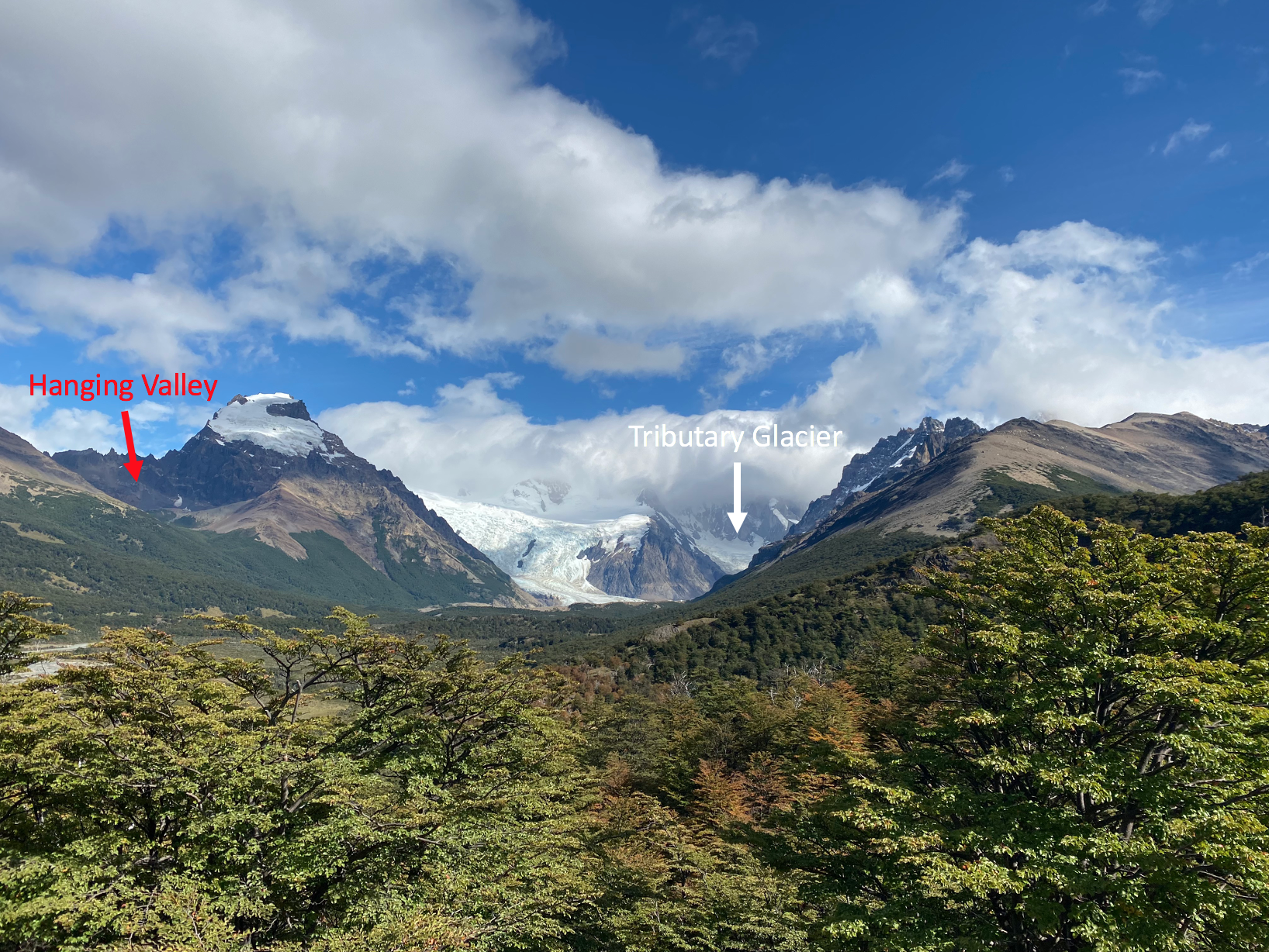
An image of modern tributary glaciers and a hanging valley near Mount Fitz Roy. This valley was once occupied by a glacier and has been carved into the mountain by glacial erosion. What remains today is a higher valley connected to the larger glacial valley below.
Similar to hanging valleys, cirque are bowl-like, concave valleys formed by glacial erosion. In the image below we see a cirque filled by a glacier. If the ice were to melt, a cirque valley would be left behind.
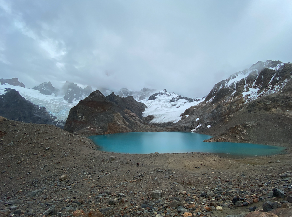
The image below also shows a proglacial lake. These lakes are formed as a glacier advances into a valley and scours out a deep depression and then retreats, leaving behind glacial material that acts as a dam, creating a lake behind it. These lakes are formed at the base of the glacier and continue to the glacially-formed dam.
In this image we can also see a number of icebergs (large chunks of ice that have separated from the main glacier) evidence that this lake is still connected to glaciers. The tour boat shown next to the iceberg in the image is holding approximately 150 people. So, this iceberg is very, very big!
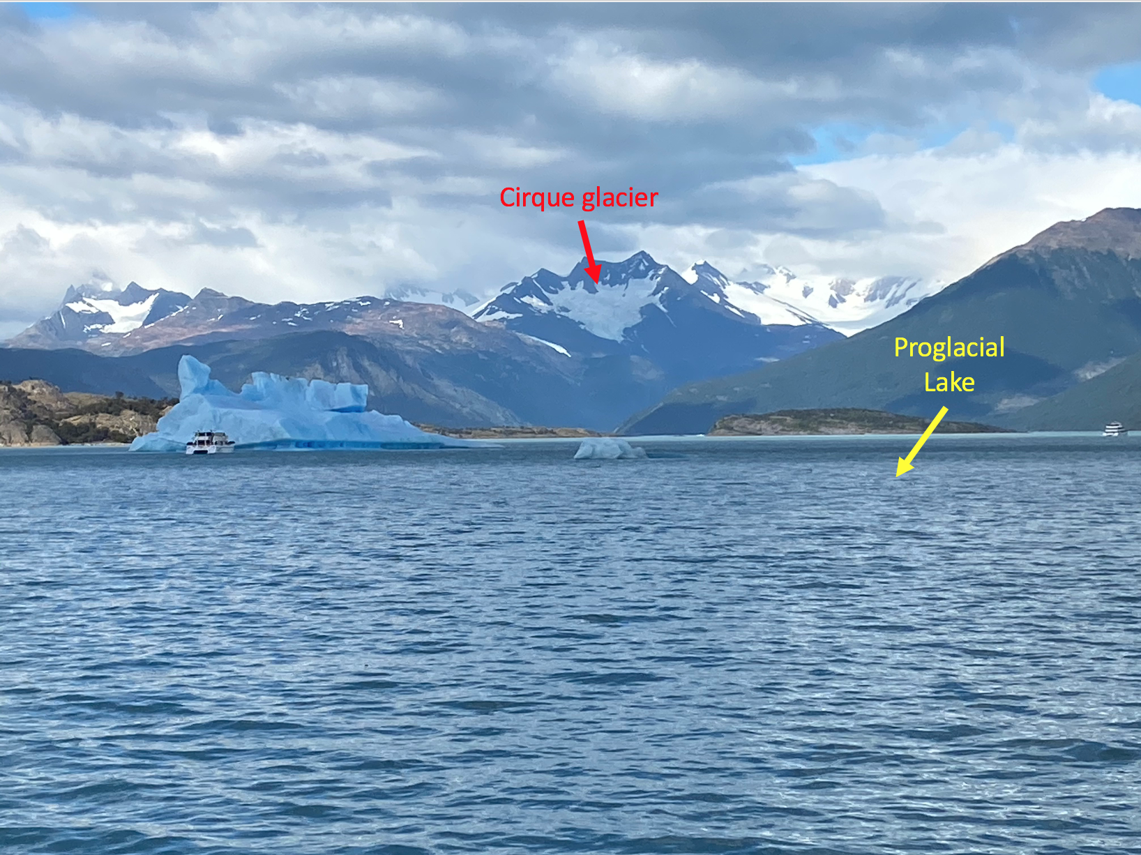
An image of a cirque glacier and icebergs on the proglacial Lake Argentino. The lake is connected to the Southern Patagonian Icefield and is fed by many glaciers today. This massive lake has a surface area of about 1,400 square kilometers (540 square miles) and is currently dammed by material from a glacial deposit that was left by the ice sheet around 30,000 years ago.
Glacial Depositional Landforms
While glaciers erode, they also deposit material. This can often occur in the same area. In the image below, taken near Upsala Glacier in the Southern Patagonian Icefield, we can see polished bedrock valley walls, a product of glacial erosion. The image also shows a lake, likely occupying a depression in the landscape scoured out by glacial erosion. However, this lake is dammed by glacial material, deposited by the ice as it retreated. Furthermore, the foreground is littered with rocks and debris that were once carried by the glacier. Thus, glacial erosion and deposition are related, interacting processes that allow for the generation of complex glacial landscapes, littered with evidence of past glacial behavior.
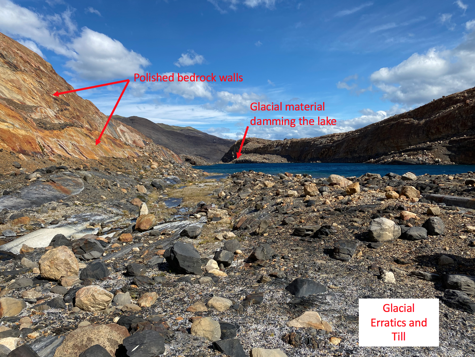
The image above includes a fine layer of very fine sediment left on the valley floor. This finely ground sediment, called glacial till is often deposited as massive outcrops of sediment. This till is generated by the continual grinding and erosion of rock material until it is deposited as a fine sediment.
Glacial moraines are one of the most distinctive glacial landforms. These landforms are made up of till and rock that was once carried by the glacier before being deposited as the ice melts and retreats. This material can come from anywhere in the landscape and debris is often transported over large distances by the ice. Moraines are seen on the landscape as long, winding hills of glacial material. Moraines can be quite large and, odds are, if you’ve gone over a hill in Minnesota, it could very well be a moraine (or another glacial depositional feature).
There are a number of distinct types of moraines. Terminal moraines mark the terminus of the ice lobe and show how far the ice lobe extended before melt and retreat. Lateral moraines are piles of debris piled along the sides of a glacier as it flows while medial moraines are when two tributary glaciers come together and debris from both ice lobes form a pile of debris between the two glaciers. Ground moraines are less clear to link directly to a location on the glacier and are, instead, a disorganized jumble of rock and debris left behind by a glacier.
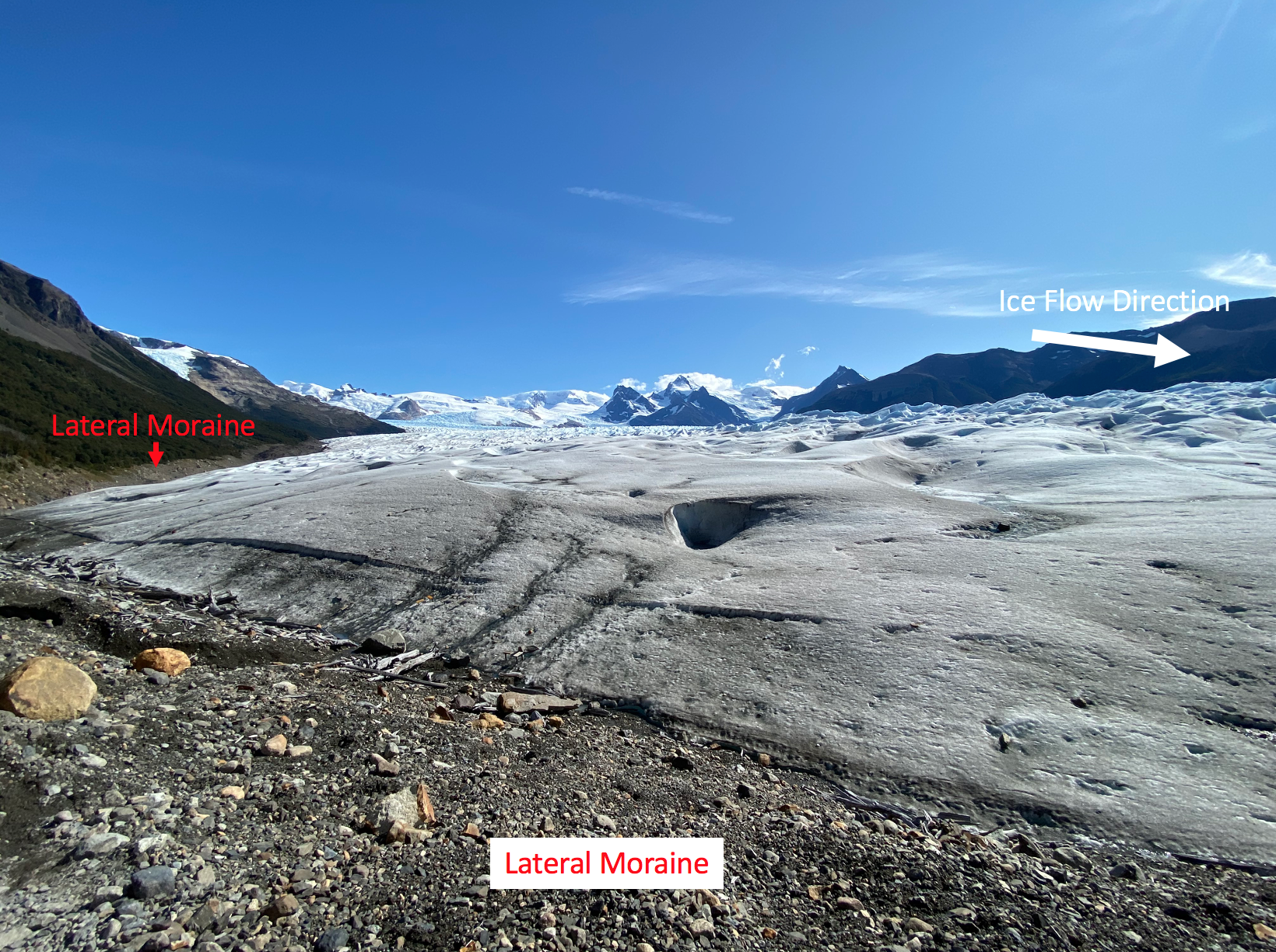
An image of lateral moraines along the edge of Perito Moreno Glacier. The terminus of the glacier is to the right of this image (indicated by the ice flow direction). Note that the moraine material is comprised of a mix of fine sediment and larger rocks. The lateral moraine in this image also runs along the trimline we noted earlier. As the glacier eroded to form the distinct delineation in vegetation, it also left behind glacial material, forming this lateral moraine.
Here is a video I took on top of a moraine near Upsala Glacier. You can see the modern glacier off on the horizon around (0:03). Note the bare bedrock walls and small lakes that have formed from the glacially-reworked topography. This small moraine I’m standing on is comprised of a mix of glacial material, including some rather large boulders and has an elongated, roughly linear ridgeline. In our research we are trying to understand when the glacier deposited this material.
Erratics
Glacial erratics are pieces of bedrock and debris that get picked up and deposited elsewhere by glacial ice. These rocks vary widely in size and can be quite large. When they are deposited, they are often deposited in an area with an entirely different rock type, making them quite distinctive on the landscape. In the YouTube clip above, you can see a member of our team sitting atop a glacial erratic. This boulder is large enough for him to sit on yet was still carried by glacial ice.
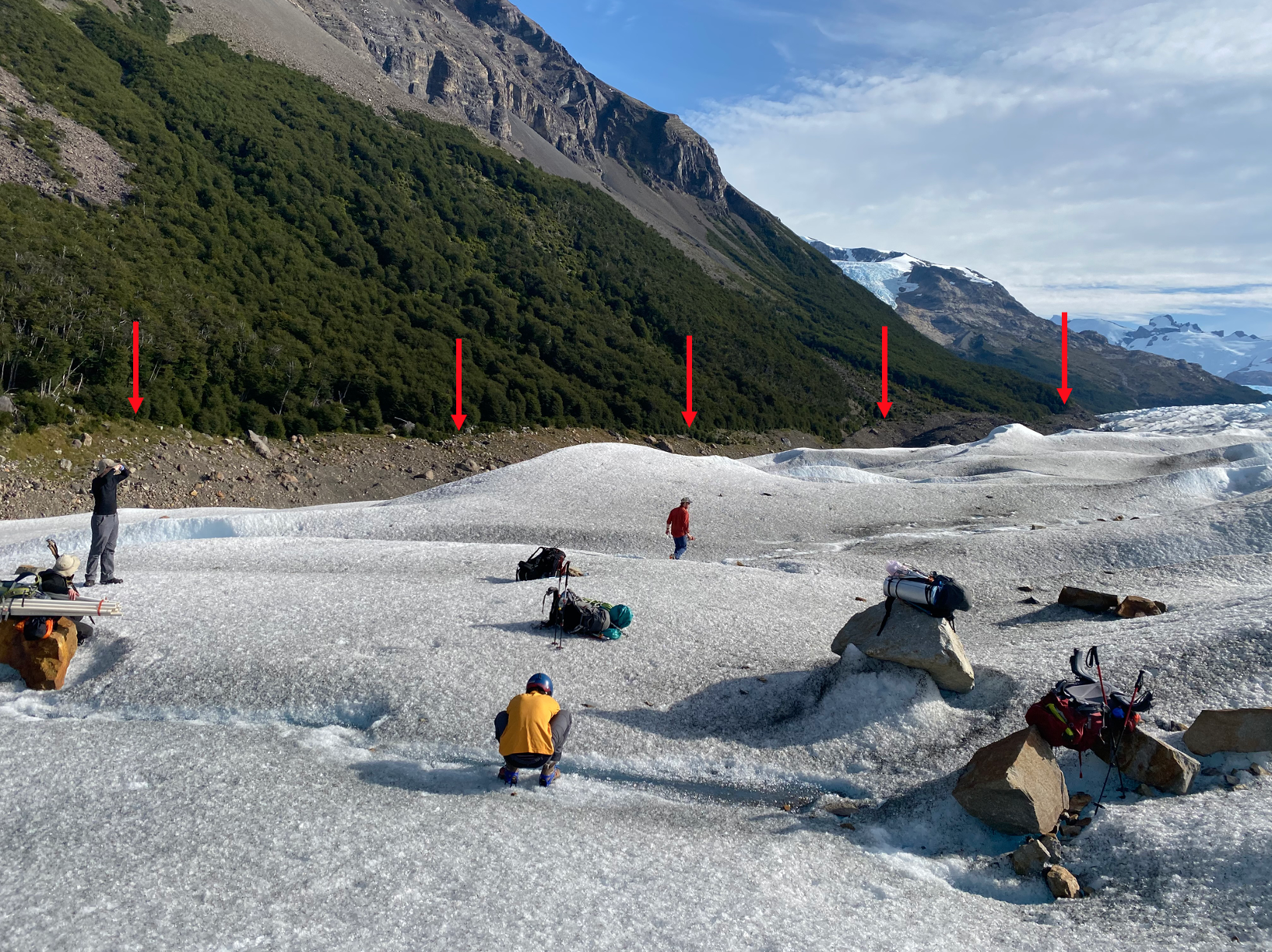
Below are a number of “future” glacial erratics. These rocks are currently being transported by the Perito Moreno glacier and will ultimately be deposited, far from where they originated.
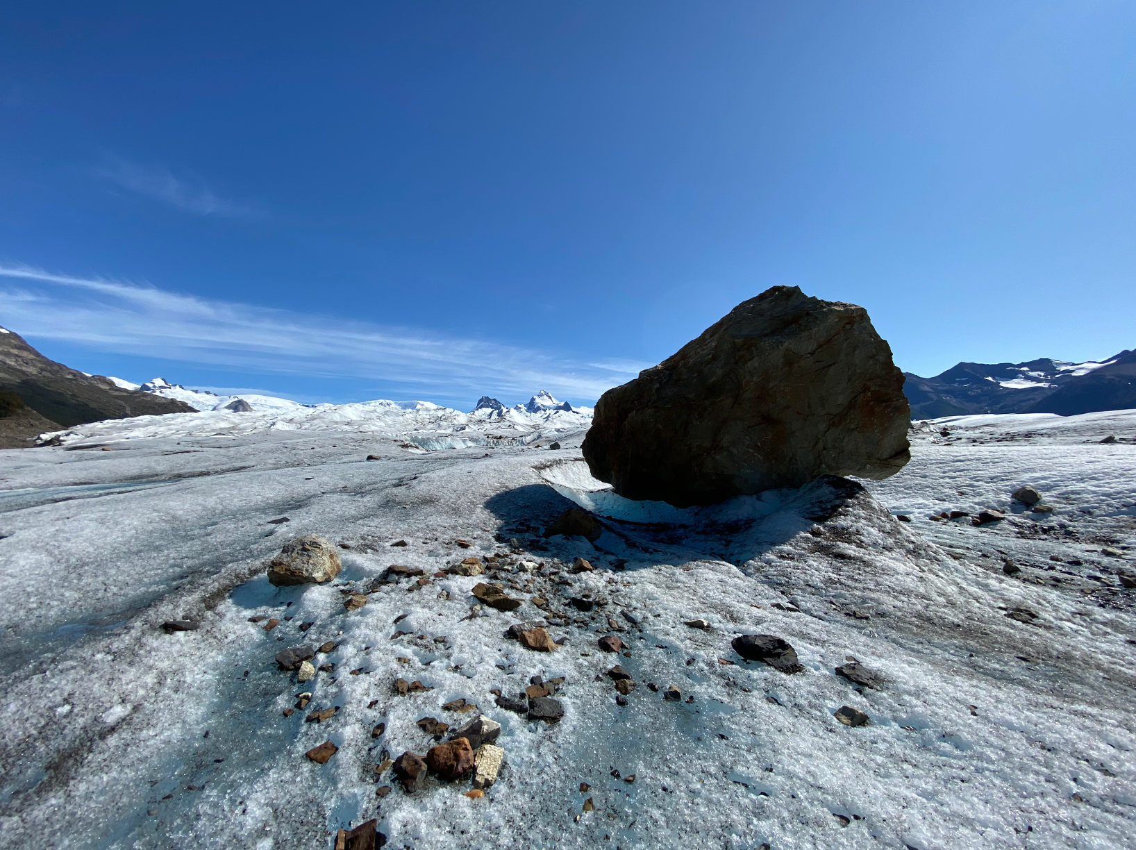
This massive chunk of bedrock is taller than a person and could have fallen onto the ice or been picked up by glacial erosion. This particular boulder was so large that we used it as a landmark during our hiking on the glacial ice.
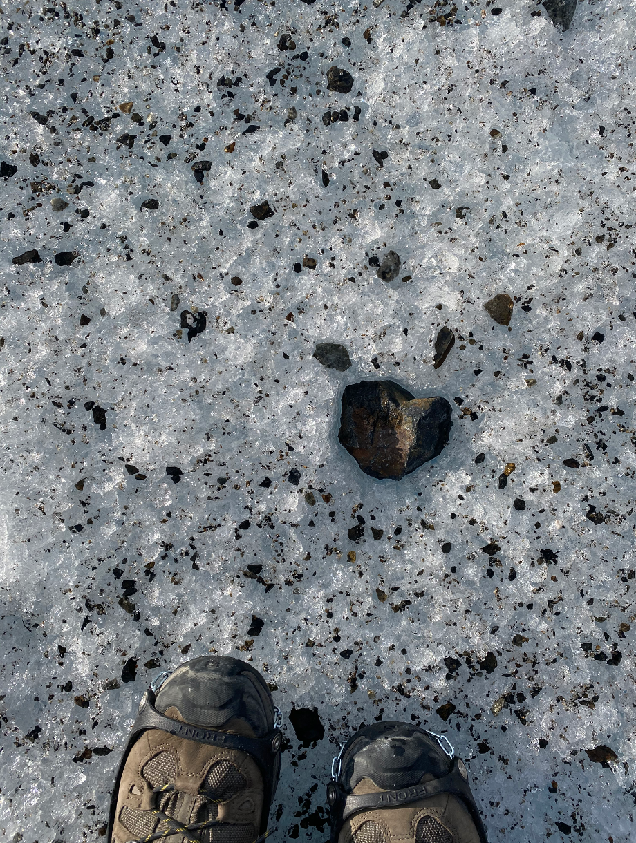
This piece of rock is considerably smaller but, once deposited, will still become a glacial erratic. Note how the edges of this rock have been rounded by glacial motion. The ice around this rock is also covered in dirt and debris. This, too, will ultimately be deposited by the glacier.
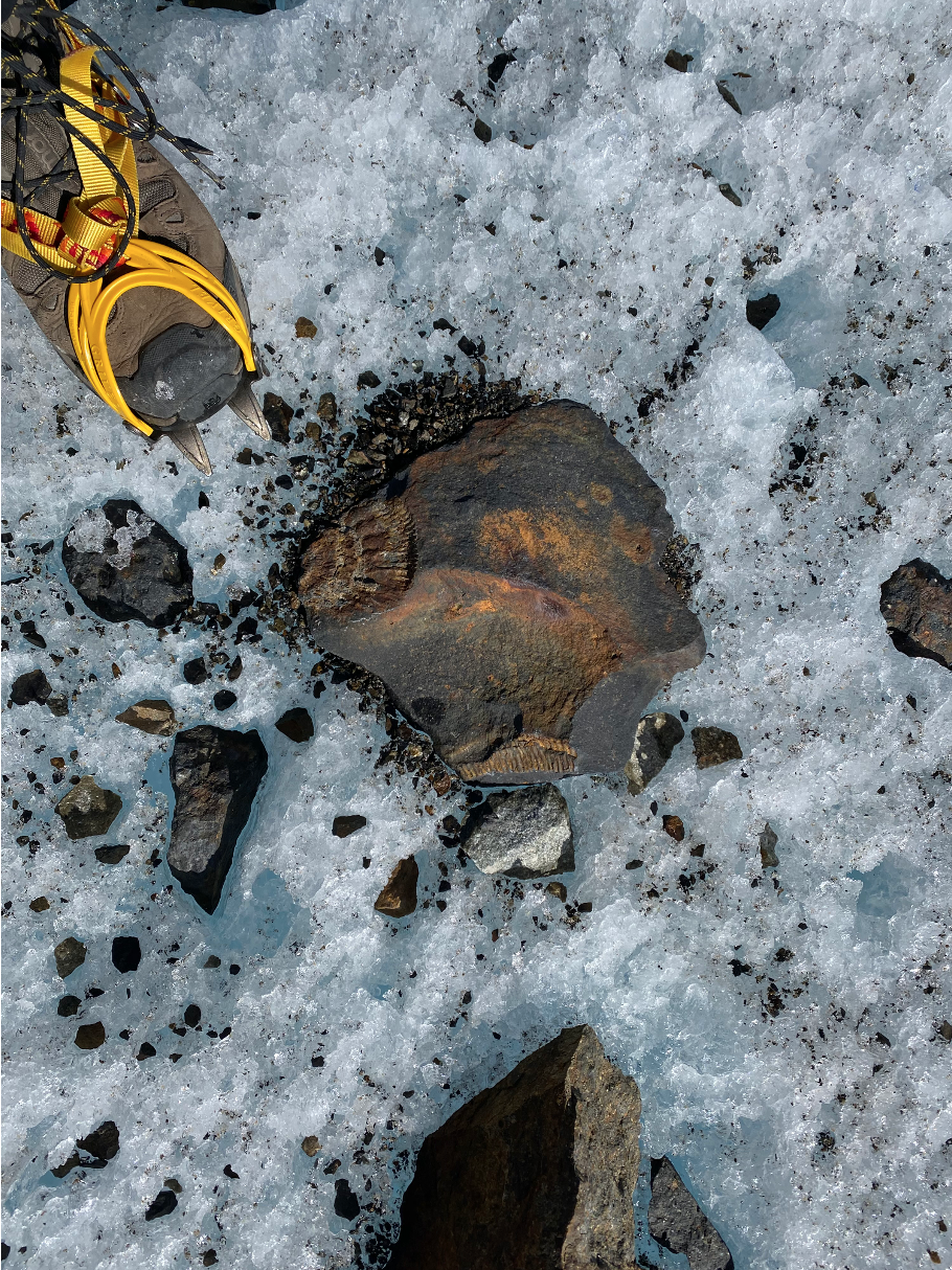
Glaciers transport all types of rock. This piece of rock on the glacier contains several pieces of ammonite (an extinct, marine mollusc) fossils. It’s amazing to think about this small organism passing its life in the ocean, then having its shell become part of a fossilized rock unit, only to be picked up by a glacier and transported many miles. All part of the geologic process and very cool to think about!
Tying It All Together
In this section we learned about a number of glacial landforms that are generated by glacial flow and retreat and how these landforms vary in scale across the landscape. These landforms remain long after glacier ice has retreated. In the next section we’ll learn about the longer-term impacts of glaciation on the non-glaciated parts of the environment around them, what we call paraglacial processes.

This work is licensed under a Creative Commons Attribution-ShareAlike 4.0 International License.